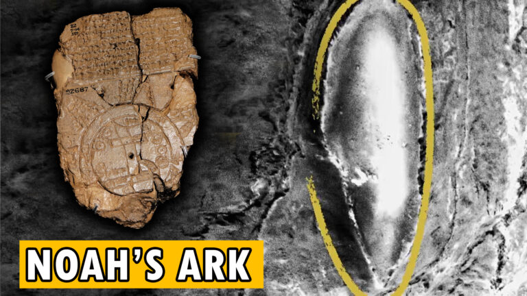
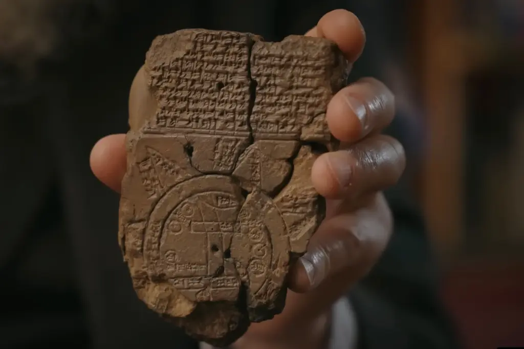
Hidden deep within the vaults of the British Museum lies a small, unassuming clay tablet that could rewrite everything we thought we knew about ancient cartography—and perhaps even biblical history itself. To the casual observer, it appears modest: a circular etching surrounded by cuneiform inscriptions, its surface worn smooth by time. Yet this palm-sized relic, known as the Babylonian Map of the World or Imago Mundi, may hold the earliest record of the true resting place of Noah’s Ark.
The Oldest Map of the World
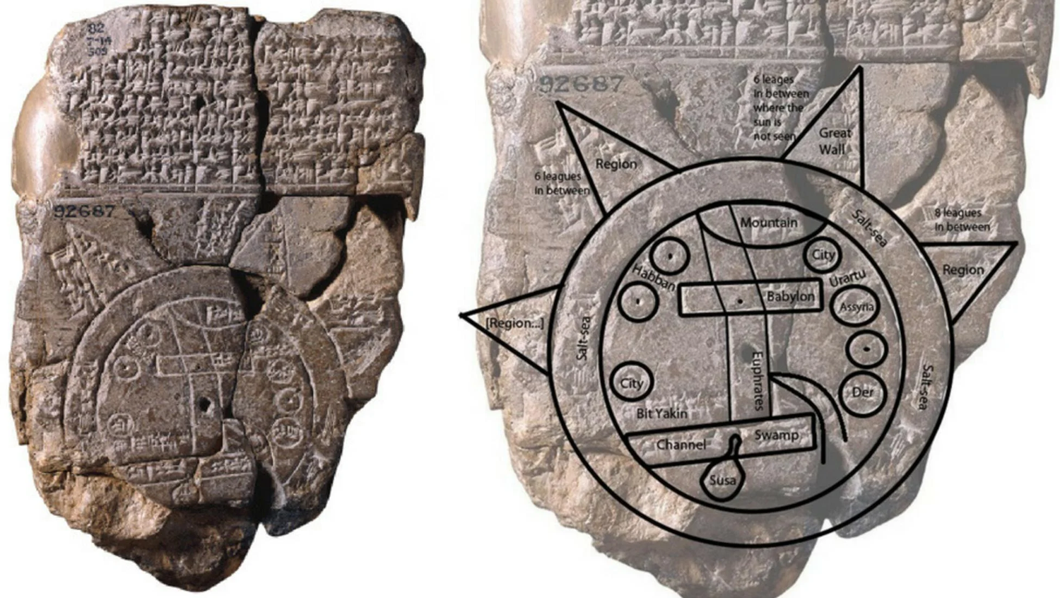
The Babylonian Map of the World, dating to around the 6th century BCE, comes from an age when Babylon stood as the intellectual heart of the ancient Near East. At its center, the map shows the Euphrates River, the lifeblood of Mesopotamia, and beside it the rectangular symbol of Babylon, the city of kings, astronomers, and scholars. Encircling this inner world is a double ring labeled “The Bitter River,” representing the great ocean that surrounded the known Earth.
Radiating outward from this circle are eight triangles—once believed to represent mythical mountains or islands. However, recent studies have revealed that these triangles may not be symbolic at all. The cuneiform text accompanying each one describes precise distances, directions, and even recognizable topographic features. In other words, the Babylonians were not simply drawing myths—they were mapping their world.
The Parsiktu Mystery: A Hidden Clue to the Ark
Among these triangular lands, one stands apart. Its inscription describes a “Great Wall” rising 840 cubits high, its trees towering 120 cubits, reachable after crossing the Bitter River for seven leagues. Within these damaged lines appears a mysterious term: parsiktu.
When British Museum curator Irving Finkel and researcher Edith Horsley rediscovered this fragment, Finkel immediately recognized the word. Parsiktu appears only once elsewhere—in the Babylonian flood epic of Atrahasis, the oldest known account of a Great Flood. In that text, Atrahasis describes his massive ship, the prototype for Noah’s Ark, as built with “planks as thick as a parsiktu-vessel.”
This was no coincidence. The presence of parsiktu on the Babylonian Map directly connects it to the earliest flood narrative known to humanity, predating the Book of Genesis by more than a thousand years.

The First Map of Noah’s Ark
When the missing fragment was reattached to the map, the puzzle came together. The parsiktu inscription aligned exactly with one of the outer triangles, suggesting that this portion of the map referred to a real, physical mountain—the site where the Ark had come to rest. The cuneiform even mentions “ribs as thick as parsiktu,” an evocative phrase hinting at massive wooden beams still visible on the mountain’s slopes.
If true, this means the Babylonian Map of the World may represent the first cartographic record of the Ark’s landing site—centuries before the story of Noah’s Ark appeared in Hebrew scripture.
From Urartu to Ararat: The Mountain of the Ark
The region described on the map corresponds closely with Urartu, the ancient kingdom located in modern-day Armenia and eastern Turkey. Linguistically, Urartu is the direct ancestor of the biblical term Ararat. The Babylonian scribes knew this mountainous land well—it stood just beyond their northern horizon, a realm associated with gods, storms, and the aftermath of the Great Flood.
The Book of Genesis echoes this same geography: “And the Ark came to rest upon the mountains of Ararat.” The plural “mountains” suggests a region, not a single peak, perfectly consistent with the Babylonian depiction. What we call Mount Ararat today is a later interpretation—an isolated summit elevated through centuries of Christian tradition and medieval pilgrimage.
Explorers and the Reawakening of the Ararat Legend
By the 17th century, European scholars and travelers had turned their eyes toward Mount Ararat, the twin-peaked volcanic massif rising between Turkey and Armenia. Reports of wooden remains, “boat-shaped” rock formations, and ancient anchors circulated widely. In 1829, the German explorer Friedrich Parrot and Armenian scholar Khachatur Abovian made the first documented ascent, fueling the belief that the Ark’s remains still rested somewhere near the summit.
In later centuries, numerous expeditions sought to uncover proof. Some explorers claimed to have found petrified wood, others described ark-shaped silhouettes seen during melt seasons. Yet the mountain’s fierce climate—its glacial flows, avalanches, and volcanic history—made verification impossible. Snow cover, shifting ice, and extreme weather erased or concealed any evidence year after year.
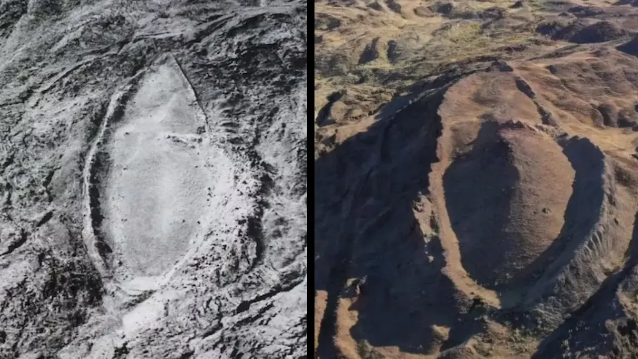
The Durupınar Formation: The “Ark” That Stirred the World
A modern twist came in 1959, when Turkish Air Force captain İlhan Durupınar noticed a remarkable, boat-shaped outline in aerial photographs near Doğubayazıt, only a few miles from Mount Ararat. The formation measured 164 meters long—close to the biblical dimensions of Noah’s Ark if scaled by common cubit measurements.
The discovery drew international attention. Adventurers such as Ron Wyatt and David Fasold claimed to find “iron fittings,” “drogue stones,” and structural patterns resembling ribs and decks. For many believers, the Durupınar site became tangible proof that the Ark had survived.
Skeptics, however, offered geological explanations. Experts noted that the site sat on a natural formation shaped by erosion, faulting, and landslides. The “ribs,” they argued, were sedimentary cracks; the “keel” was a ridge of resistant rock. Tests of supposed wooden fragments often revealed natural mineralization rather than preserved timber. Still, the allure of the site persisted, blending geology, legend, and faith into one enduring mystery.
The Ararat Anomaly and Satellite Searches
In 1949, U.S. Air Force reconnaissance captured images of a rectangular shadow near Ararat’s summit—dubbed the Ararat Anomaly. Over the years, subsequent spy-plane and satellite images showed similar dark shapes under snow, sparking waves of speculation. Could this be the remains of Noah’s Ark frozen in glacial ice?
While preservation under such conditions is unlikely, the notion cannot be entirely dismissed. A buried wooden structure, trapped within a lava tube or ice cave, could in theory endure for millennia. Modern expeditions continue to scan Ararat’s ridges using drones, LIDAR, and ground-penetrating radar, searching for anything that could match the ancient descriptions.

A Legacy Written in Clay and Stone
Today, the Babylonian Map of the World stands as more than an artifact of early cartography. It may be a window into how ancient civilizations saw their place in a world shaped by catastrophe. The connection between the map and Noah’s Ark invites us to reexamine both history and myth, blurring the line between symbolic storytelling and ancient scientific observation.
Whether or not the Ark’s timbers still lie hidden on Ararat’s frozen slopes, the enduring mystery continues to inspire exploration. Across faith, science, and archaeology, one truth remains universal: humanity remembers its beginnings through stories of survival, renewal, and the hope that, after every flood, life begins anew.